Saturday, 26 March 2022

First Trip of the Year to Herefordshire - Part 2: St Leonard's Church, Hatfield.


Full moon rising over the nearby copse on Thursday evening.


Timothy having a tipple and perusing a new book on The Mortimers.


I would really have liked to stop a few days longer but Friday was our last day as there were reasons for having to return home.  On Friday morning I decided to have a look round the church nearby at Hatfield dedicated to St Leonard.  I've walked round the church exterior and churchyard several times already but Friday's visit was to see the interior.

Lesser Celandine on the bank where I parked the car.


St Leonard's has an 11th century nave which may even be pre-Conquest it was extended west in the 14th century when the chancel was probably re-built.


I just love this bricked up doorway - it is an early Norman doorway with a lintel of three large joggled stones.  The tympanum shows opus reticulatum (square stones set diagonally).  Herringbone masonry in the wall can also be seen.


The bell turret may be medieval and was weather-boarded in 1903.


The open timber west porch is partly 14th century.


And so inside the church.


Plain Norman font which has been superseded by a 19th century one (which to be honest I thought was rather ghastly!).


Looking towards the chancel.  The chancel was restored in 1878 and rest of church in 1903 and most fitttings date from around 1800 (pulpit and west gallery).


That new font :(


I loved the pattern of brickwork in the church - some off the nave walls were rebuilt in 1723 after collapsing.


The East window by Mayer and Company 1878.


We left about 2.00 p.m and came home via Tenbury Wells and Droitwich joining the M5 much further up to avoid the road works at Worcester.

I must admit I wish I could have been there this week with the lovely weather we have been having.

Back at home Blue Tits are building a nest in the nestbox which has a camera but still no sign of frogspawn in the pond.


I hope everyone is staying safe and well.


Photos taken by me with the Panasonic Lumix FZ330 bridge camera


Reference: Buildings of England - Herefordshire Pevsner (latest edition).


Tuesday, 22 March 2022

First Trip of the Year to Herefordshire - Part 1: Titterstone Clee Hill and Tenbury Wells plus the Herefordshire Tree


Now that the site has now re-opened we spent a few days in Herefordshire last week.

Timothy glad to back!


The Herefordshire Oak - still bare but I think a slight suggestion in the colour of leaf buds to come.  First photograph taken in March as in 2020 the park couldn't open until July and last year it was April (due to lockdowns).


We arrived Tuesday lunchtime and in the afternoon did the usual click and collect for shopping at Morrisons in Leominster. Sadly, Wednesday it rained all day so we didn't bother going anywhere.

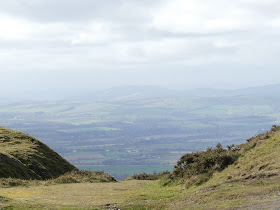
Thursday the weather was fine and as B didn't want to visit any villages (and of course he doesn't like visiting churches) I finally suggested a trip to Titterstone Clee Hill which we had seen in the distance from both Ludlow and Tenbury Wells.  There is a car park quite near the summit which saves walking all the way up which was just as well as it was SO windy and I nearly got blown away just taking photos.

Titterstone Clee Hills is 533 metres above sea-level and the third highest hill in the Shropshire Hills Area of Outstanding Natural Beauty.  Most of the top of the hill is common land used for grazing sheep, air traffic control and disused and working quarries.

Clee Hill is one of the few hills to feature on the Mappa Mundi map in Hereford Cathedral.


As you can see the views were just stunning although sadly it was quite a hazy day.  


There is evidence everywhere of mining and quarrying for a dolerite, known locally as "dhustone", which is used in road building.  Many of the industrial buildings still remain including early examples using reinforced concrete.


Also on the summit of the hill are two radar stations (not visible from the car park)  The first radar station was constructed in September 1941 and used by the RAF during World War 2.  The station was disbanded and closed in September 1957 and is now part of National Air Traffic Services Radar Network.  The smaller radar station is used by the Met Office.  Also out of sight on the summit is an Iron Age Hill Fort and Bronze Age Cairn which I would dearly love to see. Finally there is a mound of boulders formed during cold intervals of the Devensian Ice Age and called the Giant's Chair.  Hopefully we will return on a less windy day and explore further.

We stopped off also at the view point in Clee Hill village which is located 395 metres above sea level.  The Kremlin pub in the village, now closed I think, was the highest pub in Shropshire.


On the way back we stopped off in Tenbury Wells as B wanted to try and buy in Tesco a hose attachment for the kitchen tap in. They didn't sell them but he did buy some pansies to plant up in a tub.


We had a quick walk round the town centre.


A rubbish photo taken from the car but if you peer through the railings in the centre of the picture you can see what is known as Tenbury Wells Castle or Burford Castle or Castle Tump.

It may have been built before the Norman Conquest probably by Richard Le Scrope (who also built Richard's Castle which we have visited a few times).  He was a Norman invited to England by King Edward the Confessor in the late 1040's.

What was a motte and bailey castle controlled a crossing point on the nearby River Teme.  Today there is no sign of any ditches and all that remains is a mound less than 4 metres high. When we next go to Tenbury Wells I will see if I can access it.


I hope everyone is staying safe and well.

All photos taken by me with the Panasonic Lumix FZ330 bridge camera